Showing posts with label kansas city weather. Show all posts

Thursday, March 21, 2013

Kansas City To Receive Snow Today, This Weekend

The Kansas City metro has already been rocked by two major snowstorms this year, and it appears that the area will be receiving one final snow fall before spring. The KC metro is expected to receive up to three inches of snow today, with more snow coming this weekend.

Today’s snowfall is expected to start mid-morning and end by the late afternoon. Most snow will fall south of a line from Maryville to Sedalia, with little accumulation north and east of that area. The Kansas City area is expected to receive between one to two inches, while cities to the south such as Gardner, Paola, Pleasanton and Clinton will receive two to three inches. There is also a chance that a bit more snow and freezing rain could hit the metro this evening.

The biggest concern is this weekend, when the KC metro may receive upwards of six inches of snow. Meteorologists are expecting freezing rain mixed with snow to start falling from morning to early afternoon on Saturday, with heavier snowfall hitting Saturday night.

After some mild winters over the past couple of years, Kansas City has been hit hard with snow over the past couple of months. While this weekend’s storm won’t be as severe as the previous two, there will likely still be several accidents and closed roads. Kansas City will be hosting several NCAA tournament games this weekend, and the downtown is expected to be very crowded. The hazardous weather conditions and large crowds could make transportation around the metro very difficult this weekend. Kansas City residents heading downtown for the NCAA tournament games need to prepare for difficulty navigating around the metro.

KCMB Kansas City News, official kc news site with breaking stories on The Kansas City Royals, Chiefs, charity events, the 2012 MLB All Star Game, weather, sports, MU, KU, ufo sightings, dui checkpoints, Kansas City neighborhoods, nightlife, concerts, the Sprint Center, the Power and Light District and current Kansas City news articles.

Wednesday, February 27, 2013

Kansas City Recovering From Second Snow Storm

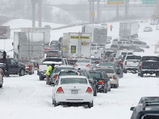
After being hit with one of the worst winter storms in years, Kansas City got a second helping of snow and ice yesterday that continued into this morning. The second storm featured heavy snow that has caved in roofs, broken trees and damaged power lines.

Over 100,000 people in the metro lost power from the recent storm, which featured 10 to 12 inches of snow across Johnson County to Lee’s Summit. Areas north of the Missouri River received around eight inches of snow, while the area between Pleasant Hill and Warrensburg received up to 14 inches. As a result from yesterday’s and Thursday’s snowfall, most of the Kansas City metro has received between 16 and 25 inches in less than a week.

The latest storm did not create nearly as many traffic problems as Thursday’s, mostly because more Kansas City residents chose to stay home during the day. Few roads were blocked, which marked a significant improvement over Thursday’s snowfall, when hundreds of abandoned vehicles blocked roads and highways across the metro. Despite less people on the roads, there were still several traffic accidents. Many cars and snowplows attempting to brave the conditions slid off roadways, and many roads were still in poor condition.

Most KC metro schools closed yesterday, and many decided to close today as well. Shawnee Mission, Blue Valley, Olathe, Kansas City, KS, Kansas City, MO Lee’s Summit, Belton, Raymore-Peculiar, Independence and Grandview schools are all closed today and will reopen tomorrow.

Kansas City International airport once again had to cancel flights due to the weather. Around 100 flights were cancelled yesterday, most of them coming in the morning. Several KC metro shopping areas and malls also closed, including Independence Center, Legends Outlets, Oak Park Mall, Lee’s Summit shopping centers, Town Center Plaza, Ward Parkway Center and most stores in Zona Rosa. Most of these areas have reopened today, and customers can call stores or visit their websites to check that they are open.

KCMB Kansas City News, official kc news site with breaking stories on The Kansas City Royals, Chiefs, charity events, the 2012 MLB All Star Game, weather, sports, MU, KU, ufo sightings, dui checkpoints, Kansas City neighborhoods, nightlife, concerts, the Sprint Center, the Power and Light District and current Kansas City news articles.

Friday, February 22, 2013

Kansas City Recovering From Winter Storm

Kansas City is still trying to recover after being hit by a massive winter storm over the past 24 hours. The metro was blanketed in snow, with accumulations of anywhere between 10 to 13 inches.

The snow fell at a rate as rapid as three inches per hour, which quickly made roads dangerous and led to many motorists being stranded or, even worse, wrecking their vehicle. Drivers who had a car stranded or towed are urged to call the city at 816-607-2000 before visiting the city tow lot to retrieve their vehicle. Some vehicles are located at the impound lot at 7750 E. Front St., while others may have been taken to a Missouri Department of Transportation site.

While the snowfall has stopped, the Kansas Department of Transportation is still urging those in the metro to avoid driving, if possible. Many roads are still in poor condition, and road crews and towing companies are still extremely busy.

The storm forced Kansas City International Airport to close down, however KCI has reopened today. A UPS plane was the first to land, and reported good traction on the runway. While the airport is open, many flights have been affected, and a total of 51 flights were still cancelled as of this morning. Anyone traveling in the near future should check their flight status at FlyKCI.com.

KCMB Kansas City News, official kc news site with breaking stories on The Kansas City Royals, Chiefs, charity events, the 2012 MLB All Star Game, weather, sports, MU, KU, ufo sightings, dui checkpoints, Kansas City neighborhoods, nightlife, concerts, the Sprint Center, the Power and Light District and current Kansas City news articles.

Tuesday, February 19, 2013

Dangerous Winter Storm Approaching Kansas City

A dangerous winter storm is making its way to the Kansas City area. Meteorologists say that this storm could be the biggest the region has faced in years. The storm is expected to hit the Kansas City area late Wednesday night and continue through Thursday.

The Thursday morning commute could be extremely problematic for drivers. Areas to the north of Kansas City are expected to get up to six inches of snow, while the Kansas City metro will likely get a dangerous mix of snow, sleet and freezing rain. Areas to the south of Kansas City will likely see a mixture of rain and freezing rain.

The largest amount of snow is expected to fall between Leavenworth and Richmond, MO, while St. Joseph will receive a heavy amount of snow as well. The largest amount of ice accumulation will likely take place in a line from Paola, KS to Warrensburg, MO. Areas south of US 50 highway, including southern Kansas City, are expected to receive the most ice from the storm.

A winter storm watch has been issued to the entire Kansas City region, including the counties of Atchison, Miami, Linn, Leavenworth, Wyandotte and Johnson in Kansas and Buchanan, Clinton, Caldwell, Platte, Clay, Ray, Jackson, Lafayette, Cass, Johnson, Bates and Henry in Missouri. This includes the cities of Leavenworth, Overland Park, Olathe, Parkville, Kansas City, Harrisonville and St. Joseph.

Due to the approaching storm, grocery stores across the metro were packed yesterday with people prepared to be stuck in their homes for a few days. Kansas City residents have also taken interest in the storm due to the Weather Channel’s recent announcement that they will start naming winter storms this year.

KCMB Kansas City News, official kc news site with breaking stories on The Kansas City Royals, Chiefs, charity events, the 2012 MLB All Star Game, weather, sports, MU, KU, ufo sightings, dui checkpoints, Kansas City neighborhoods, nightlife, concerts, the Sprint Center, the Power and Light District and current Kansas City news articles.

Thursday, December 20, 2012

Kansas City Hit Hard By Winter Storm

Kansas City has endured its first winter storm of the season, and many metro residents have spent the day battling slow traffic, closed roads and even power outages.

The roads around Kansas City were terrible all morning, as interstate traffic in most areas was 30 mph or less. Strong winds had blown the snow around on the roads, which has caused several accidents, most notably on I-29 near St. Joseph and the Kansas City International Airport. Most major roads in the KC area were not treated overnight, making  many morning commutes last hours.

Kansas City Power & Light has reported that 2,000 in the zip code of 64134 had lost power this morning, while 1,400 Blue Springs customers and 1,600 Lenexa customers also lost power. More scattered outages were also reported in Leavenworth and Olathe.

Most of the major school districts closed today, including Basehor-Linwood, Blue Springs, Blue Valley, Bonner Springs, Grain Valley, Kansas City, Kan., Kansas City, Kearney, Lawrence, Lee’s Summit, North Kansas City, Park Hill, Platte Co., Raytown, Shawnee Mission, Tonganoxie and West Platte.
The snow fall is expected to end soon, but strong winds are forecasted to continue well into the afternoon. Drivers need to continue to exercise extreme caution on the roads, as these winds have combined with snow on the ground to cause several accidents already.
KCMB Kansas City News, official kc news site with breaking stories on The Kansas City Royals, Chiefs, charity events, the 2012 MLB All Star Game, weather, sports, MU, KU, ufo sightings, dui checkpoints, Kansas City neighborhoods, nightlife, concerts, the Sprint Center, the Power and Light District and current Kansas City news articles.

Wednesday, December 19, 2012

Winter Storm Approaching Kansas City

Kansas City residents have had the luxury of enjoying a mild winter so far, but that appears to be changing tonight. A winter storm is heading towards KC and is expected to bring snow and blizzard conditions to many areas in the greater metro.

It appears that the worst part of the storm will actually pass north of the city and mostly hit Iowa, which is some good news. Iowa is expected to receive six to 10 inches of snow, while Kansas City will likely only receive a couple inches of snow. As much as seven inches of snow is expected in areas such as St. Joseph and Kirksville. Rain is expected to begin to fall around Kansas City this afternoon, which will turn into snow later this evening.

There is also a high chance of thunderstorms with severe winds hitting the region. With expected winds of 25 to 35 mph and gusts of 45 to 50 mph, many areas around Kansas City could experience blizzard conditions.

The Kansas Highway Patrol has issued several trips to drivers that will be battling these conditions. The Patrol suggests slowing down, avoiding cruise control, using headlights, as well as replacing wiper blades and checking tire pressure and tread. It is also important to check that your vehicle’s fluids are all full. Pickup truck drivers need to add sand bags to their beds to help with traction control, and all vehicles should have a shovel in the trunk.

All Kansas City residents need to take extreme caution, even in areas where there is not an abundance of snow. Last year, 55 crashes occurred in Overland Park during the first five hours of a snow storm, despite a light amount of snowfall.

KCMB Kansas City News, official kc news site with breaking stories on The Kansas City Royals, Chiefs, charity events, the 2012 MLB All Star Game, weather, sports, MU, KU, ufo sightings, dui checkpoints, Kansas City neighborhoods, nightlife, concerts, the Sprint Center, the Power and Light District and current Kansas City news articles.

Sunday, April 15, 2012

Weather - Tornados Strike Oklahoma, Storms Likely for Kansas City - KC News


There was some nasty weather out on the plains yesterday as tornados touched down in Woodward, Oklahoma killing 5 people and injuring 20.  Lighting struck the siren warning system and the tornado sirens did not sound.  At this time over 3000 people are out of power in Oklahoma.  Weather for Kansas City looks to be cloudy with a chance of intermittent thunderstorms depending on what part of Kansas City you live in.

Yesterday, April 14th, over 100 tornado warnings were issued across the Midwest.  A state of emergency was declared in Sedgwick County, Kansas and Kansas Governor Sam Brownback is scheduled to tour the damaged areas today - what the hell good will that do?  Anyway, it seems the town of Thurman, Iowa got hit the hardest, with almost 75% of the ENTIRE town destroyed!  Hope the local bar is still standing.  The American Red Cross is focusing food and shelter efforts on the areas of Kansas, Iowa, Oklahoma and Texas until the damage is repaired and the people left homeless are taken care of.  The weather in Kansas City today will be a slight reflection of the storms that passed through yesterday and last night, with cloud cover for most of the day and a chance of thunderstorms until early evening.  The 5 day weather conditions for Kansas City will see the sun come out again on Monday with mild temperatures in the low 70's and no rain in sight until Thursday.

In the wake of the terrible tornado that rocked Joplin, Missouri last year, officials and government agencies are quicker to issue warnings and watches during this year's tornado season.  Too bad it didn't thunderstorm on Friday night and "wash out" that hideous Royals home opener!  


Kansas City News, official kc news site with breaking stories on The Kansas City Royals, Chiefs, charity events, the 2012 MLB All Star Game, weather, sports, MU, KU, ufo sightings, dui checkpoints, Kansas City neighborhoods, nightlife, concerts, the Sprint Center, the Power and Light District and current Kansas City news articles.

Wednesday, August 3, 2011

Record High Temperatures hit KC Area Tuesday

"Is it hot enough for ya?!?!" What kind of asshole says that. No, it's not hot enough for me, I like to have my balls actually melt to the inside of my leg. Geez, what a dickhead.

Record highs were recorded all around the metro today. Officially, the high temperature was 107 at the airport breaking the old record of 104. Those of us south of the river know that it reached 110 plus in some areas. Olathe's official reading was 110. That was the hottest recorded temperature there since the 1950s.

The heat caused problems with electricity in some areas. The prolonged heat wave really puts stress on the system. Shawnee Mission Medical Center reported a power outage at the hottest part of the afternoon on Tuesday. You can check for outages 24/7 on KCPL's website. Of course, that does you a lot of good if you're the one without power.

Today, and the rest of the week, it should be considerably cooler, like 96. Enjoy your cool weather Kansas City!! On the bright side, the sexy ladies tend to wear a little less on those really hot days.

Monday, June 27, 2011

Storms Overnight Knock Out Power Again

Two waves of severe weather this morning in the Kansas City area downed trees and knocked out power again. Almost 46,000 customers had lost power according to KCPL, many of whom lost power the last time strong storms moved through the area. In the city, and older areas with mature trees and overhead power lines were the strongest hit.

For many today will be spent cutting up downed trees, or maybe buying a generator. The good news is that the weather for Monday and Tuesday looks fabulous. Get out and enjoy it!

Northwest Missouri actually got the brunt of this storm, with a brief tornado touchdown near Maryville on Sunday evening. There were also reports of cars blown off the road, and large trees down onto power lines.

Monday, June 6, 2011

Extreme Heat, Humidity Hit Kansas City Area

Summer weather has hit Kansas City already. The Forecast calls for extreme heat and humidity through Wednesday of this week. Highs will be in the mid 90's with heat indexes over 100 degrees. These conditions have prompted the National Weather Service to issue a heat advisory for the Kansas City metropolitan area.

The Kansas City School district, one of the few still in session, has sent students from East and Northeast High Schools home for the day because these two facilities do not have air conditioning (I never went to an air conditioned school - my how times have change - wussification of America). Cooling centers have been opened throughout the Metro area to help those who do not have air conditioning. People are also advised to check on neighbors, especially the elderly and make sure pets have adequate water and a shady place to hang out.

If you have to be outside, make sure you drink plenty of water - and though beer is mostly water, it will dehydrate you in this kind of heat. Loose fitting, light colored clothing is also helpful. And for God's sake, DO NOT leave any living creature in a vehicle with the windows closed - cars can get to a deadly temperature in a hurry.

Friday, February 25, 2011

Another Record Snowfall Pounds the Kansas City Area

Another record snowfall for the Kansas City area, as KCI recorded 6.2 inches of snow. That shattered the old record of 3.8 inches set way back in 1934. Though not everyone got a half foot of snow, everyone in the Kansas City metro got a taste. Snowfall Totals ranged from 2" in the southern parts of the area, up to around nine inches to the northwest. Even die hard snow lovers have had it with winter in Kansas City that if you remember didn't even really start until January. We can hope, but don't expect this to be the last of it either.

There is another storm system setting up that could bring snow to Southern California before bringing heavy rains and possible snow Sunday into Monday.

Hang in there folks it can't last much longer. Check out some snowfall totals from around the Metro.

Overland Park - 2.2 inches
KCI - 6.2 inches
Lees Summit - 2.7 inches
Leavenworth - 8.7 inches
Gran Valley - 1.5 inches
Independence - 4.0 inches
Blue Springs - 4.0 inches
St Joseph - 8.4 inches
Bonner Springs - 5.1 inches
Pleasant Hill - 1 inch

Wednesday, February 2, 2011

Kansas City Getting Back to Normal After Blizzard

The Great Blizzard of 2011 has come and gone. We survived. Quite a storm, with I-70 shut down for some time in Missouri from State Line to State Line. I'm sure it's happened before, but I can;t remember it. Officially, (at KCI), we had 8.9 inches, but more to the south and east. I estimate about 12-13 inches in my driveway in Lee's Summit. It took me two hours to shovel this morning, made more difficult with the two and a half foot pile the snow plow left at the end of my driveway. If this bullshit keeps up, I'm going to have to get a snow blower. But I guess I shouldn't complain, at least my street got plowed. Lee's Summit does a beautiful job with snow removal and they should be commended.

Kansas City on the other hand is a JOKE. I saw the City spokesman on the news telling people to be patient, they should have it under control "by the weekend". Weekend? It's freaking Wednesday - it is unacceptable for streets not to be plowed by the end of today. Kansas Citians should expect more from City Hall.

Snowfall Totals from around the area:
KCI - 8"
Sedalia, Butler, and Warrensburg - 18"
Overland Park - 9"
The Plaza - 11"
Blue Springs - 13"
Olathe - 12"
Wichita - 5"
Lawrence - 10"

Monday, January 31, 2011

Kansas City Area Braces for Another Round of Snow

If you believe the hype, this could be the biggest snow storm Kansas City has seen in 50 years. I've lived here my whole life; usually the amount of hype is inversely proportional to the amount of snow we actually get. That being said, it sure looks like we are going to have at least a moderate snowfall, with higher accumulations to the south, especially southeast.

The consensus seems to be 4 inches up to a possible 14 inches, depending on where in the area you are at. This does not bode well for Those who live in Kansas City Proper and do not own a 4WD vehicle. Unplowed streets with 10 inches of snow or more would be impassable for days (we are looking at temperatures below zero following the storm.) To make matters worse, the forecast also calls for strong winds making drifting of snow a real problem as well.

I, for one, will be at home in my jammies and slippers watching the snow. I recommend you do the same.

Monday, September 20, 2010

Weekend Storms Wreak Havoc Over Kansas City Area


Bookmark and Share

Strong storms rolled through the Kansas City Area on Saturday evening accompanied by strong winds and large hail. Some of the worst damage was in the Northland where winds close to 90 mph tore through the area. As of this morning, KCP&L reports roughly 1400 are still without power North of the River. This is down from the nearly 20,000 that were powerless immediately following the storm. The utility will be handing out dry ice today to those without power, bring a cooler with you to the K-Mart parking lot on Vivian Rd.

Also hard hit was Smithville Lake. The storm did $500,000 worth of damage to G Dock at Paradise Pointe Marina. That dock was a total lose, and some damage was done to surrounding docks. Large trees were downed around the Lake, and power is not restored in that are either.

Large hail around town did significant damage including the Independence Center where a skylight was broken. The mall had to be partially evacuated. Cars and roofs were heavily damaged by hail up to SOFTBALL sized. Amazingly there were no injuries reported in any of the incidents across the Kansas City Region. More good news, no more storms expected until at least Wednesday, giving folks a chance to clean up.

Tuesday, December 29, 2009

Kansas City Homicide Rate - KC Murder Rate News


Bookmark and Share


Kansas City homicide rate statistics are staggering at around 100 per year.

What I've noticed is that we do a great job of keeping it a secret. Look at all of the murders that occurred in Westport this year - at least 30+ - but strange, most of you didn't even know that. Westport murders are not the focus of this blog but I thought that I might point out that every Friday and Saturday night around 12am Westport turns into a sort of "ghetto round-up" - where all of the minorities (or are they the majority now) cruise around in their pieces of crap hood cars shooting other people and mostly each other. In other words, don't go to Westport after dark - ever - especially if you're white.

Anyway, back to the blog about the Kansas City homicide rate - the saddest part about it is the news reporting. You can turn on the news after any given Kansas City weekend night and hear something like this:

"Welcome to (insert news channel) - we're going to talk mostly about the weather, but in other news there were 2 people killed last night at (insert ghetto address) - now we move quickly on to the important news...we just got a report that a small girl who resides in Overland Park has skinned her knee! We're going live to the site of this horrible accident. The Overland Park police have blocked off the dangerous sidewalk where the little girl fell on her bicycle and we have word that they will be tearing it down.

The Kansas City news skips over the murders that occur in the ghetto so fast it's hilarious. But oh my god if something happens to a resident of Overland Park or Mission Hills - we're talking bring in the helicopters and CNN.

Oh yeah, now back to the weather.

Friday, July 31, 2009

Kansas City Weather - AWESOME!


Man, I hope you guys are out enjoying this awesome weather. Played 27 holes yesterday - but had to work today.

Found a really cool webcam today that has a nice view of a field that often has deer running around in it - in case you are one of the poor folks trapped inside at work on a nice day you can log in and have a nice view of the outside and take a little break.

Here's the site: Nature Webcam

DISCLAIMER

This is a legally confirmed "open forum" website that is not responsible for any content posted within. The opinions, articles and comments on this site do not reflect the opinions of the owner of this site, or it's subsidiaries.